Research
The "Geomorphology and Environmental Systems" research group primarily focuses on mountain permafrost distribution and dynamics, sediment connectivity, late- and postglacial landscape evolution, natural hazards, and global environmental change. Detailed information on ongoing and completed research projects, along with the relevant contact persons, can be found on this website.
Current research projects investigate slope (in)stability, periglacial (permafrost) processes and sediment budgets and dynamics in mountain systems, as well as interdisciplinary research in the fields of natural hazards and disaster management.
The application of modern field and laboratory methods such as geomorphological mapping, geophysical techniques, hydrogeochemical analyses, absolute age dating, and morphometric DEM analysis are complemented by satellite and UAV-based analyses.
Research Interests
- High mountain geomorphology
- Sediment budgets
- Mass movements (landslides)
- Permafrost and periglacial processes
- Natural hazards and risks
- Geophysical applications in geomorphology
- GIS and digital terrain analyses
Research Regions
- European Alps (Valais, Wetterstein, Dolomites, Hohe Tauern)
- Rocky Mountains, Colorado Front Range/ USA
- Andes of Argentina
- Chilean Coastal Cordillera
- German upland (Eifel)
- Ahr valley (Germany)
Methods
Classic & modern field methods (see equipment)
- Geomorphological mapping
- Remote-sensing (drone- and satellite-based)
- Geophysical surveying (GPR, ERT, SRT)
- Drilling and soil sampling
- etc.

HyPerm
In the HyPerm project we investigate the spatial distribution, geomorphological characteristics and hydrological significance of Andean permafrost in the Agua Negra catchment (Province San Juan, semiarid Andes of Argentina).
We hypothesize that a significant part of the (seasonally) thawing active layer of periglacial landforms contributes to the overall discharge and groundwater recharge. Our findings will significantly improve our knowledge regarding the occurrence and hydrological importance of permafrost in the semiarid Andes.
Ahr valley
Extreme rainfall from July 12 to 19, 2021 caused severe flooding in western Germany and adjacent regions in Belgium. The rain hit an area with high soil moisture and largely exhausted retention capacity of the ground. Widespread surface runoff and sometimes even sheet flow was the consequence. The water was channeled in the often very narrow valleys of the rivers Ahr, Erft, Rur, Kyll, Prüm, Wupper, Ruhr and their tributaries. Streams and rivers overtopped their banks almost everywhere. Massive erosion, scouring and undercutting of hillslopes, roads, railways, and buildings took place and trees fell.
It was the costliest disaster due to a natural hazard in Germany in recent history, with losses in the order of 33 billion euros (USD 40 billion) and 189 fatalities - more than in any other flood in Germany in the past 50 years. With our research we want to contribute to a better understanding and prediction of natural hazards to reduce vulnerability and prevent such disasters in the future.

EUMA- Project
Heat waves and devastating forest fires in Europe and other parts of the world forcefully remind us of the dramatic effects of climate change. They demonstrate that disasters can reach a magnitude to which individual countries can no longer respond adequately and require international assistance. The postgraduate Master's program "Master of Disaster Management and Risk Governance" at the University of Bonn is part of a European consortium aiming to strengthen a network of postgraduate programs in the field of disaster risk and crisis management. The project is funded by the European Commission and started in January 2024 with a duration of two years.
EifelfloodS
The severe flooding caused by extreme rainfall in mid July 2021 in several catchments in the Eifel region of western Germany not only caused rapidly rising water levels and violently flowing streams, it also mobilised huge amounts of woody vegetation, sediments and debris. This often led to blockages (clogging of rivers by the entrained material) and thus to non-linear flow dynamics, incision of slopes, lateral and deep erosion down to their headwater streams. Massive gravitational mass movements such as landslides and debris flows also occurred.
To enhance future forecasting through a robust database and to effectively understand the development of recent events and damage processes, there is an urgent need for high-resolution remote sensing data combined with fieldwork in the affected regions.


ArcDune
In the ArcDune project we map aeolian sand dunes in Northern Sweden, Norway and Finland (part of Sápmi) by developing a systematic, semi-automatic mapping approach (GEOBIA), interpret the dunes’ distribution and orientation in their geomorphological setting, apply radiocarbon dating and luminescence dating techniques to constrain the timing of dune stabilization and reworking, and combine the mapping interpretation with geochronological data.
The project is carried out in in cooperation with Daniel Hölbling (Paris Lodron University Salzburg) and Thomas Stevens (Uppsala University) with the overall aim to constrain landscape evolution and climate forcing in the European Arctic.
Completed Projects
- COVIDemX3 - Dementia and COVID-19 in New Zealand, Chile, and Germany: Cross-country learning for resilience in health care system. Project start: 2020 (funded by DZNE Witten, DFG)
- EarthShape - Earth Surface Shaping by Biota, A German-Chilean Research Initiative. With contributions in the two geomorphological sub-projects "Sediment storage & Connectivity" and "Bio-Geomorphology". Project start: 02/2016 (funded by DFG)
- Postglacial fan evolution in the Upper Rhone Valley, Switzerland - gradual or catastrophic? (PhD project Dr. Anna Schoch-Baumann)
- PermArg - Rock glacier permafrost in the Central Andes of Argentina: regional distribution – ice content – hydrological significance. Project start: 11/2015 (funded by DFG)
- „Atlas VR” - knowledge management for Disaster Risk Management. Developing an atlas of vulnerability and resilience.
- MOREXPERT - Monitoring potential hazardous rock walls and slopes in mountain regions - development of an expert system and adaptation strategies (COMET - K1: Centre for Climate Change Adaption Technologies)
- Visualisation of landforms and geomorphic process domains using regional data sets - creating a digital geomorphological map of the European Alps (GIScience Doctoral College - DK 1, funded by FWF)
- SourceSink - Quantifying Late and Postglacial sediment fuxes and storage in nested alpine catchments (ESF - Topo Europe Programme, funded by FWF, 2008-2011)
- SedyMONT - Sediment budgets of glacier forefields (Pasterze & Obersulzbachkees, Hohe Tauern, Austria) (ESF - Topo Europe Programme, funded by FWF, 2008-2011)
- PermAfrost - Permafrost-Glacier Interaction - Process Understanding of Permafrost Reformation and Degradation (funded by Austrian Academy of Science, 2010-2012)
- SCALA - Scales and Hierarchies in Landform Classification (Prof. Dr. Thomas Blaschke, University of Salzburg)
- CLIMSLIDE - Climate Change and Adaption of Critical Infrastructures and Lifelines for dynamic landslides (COMET - K1: Centre for Climate Change Adaption Technologies)
- SIMA - Simulation of high velocity mass movements (COMET - K1: Centre for Climate Change Adaption Technologies)
- SEDAG - Sediment cascades in alpine geosystems (DFG 2000-2008)
- RMT - The use of Radiomagnetotellurics in Geomorphology (DFG 2004-2008)
Surface scanning and positioning:
Multicopter
Hardware:
- DJI Phantom 4 RTK
Software:
- Agisoft Metashape Professional
Method:
Unmanned aerial vehicles (UAVs), also referred to as drones and multicopters, offer a great variety of applications in geomorphic research. Commercially available UAVs can be operated easily through an Android/IOS app. Our working group uses a DJI Phantom 4 RTK for high-resolution photogrammetric surveys. Due to the D-RTK integrated within the aircraft and the additional DJI D-RTK 2 GNSS ground mobile station, which exchange correction data during flight, the Phantom 4 RTK provides high-precision data for centimeter-level positioning. From these imagery, we can produce high-resolution digital elevation models and orthophotos using the photogrammetric software Agisoft Metashape. Our aim is to compare DEMs and orthophotos collected in different points of time to detect geomorphic changes.

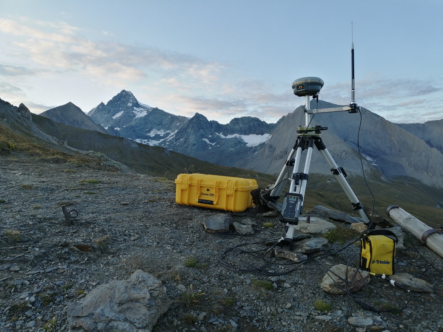
Differential GPS: Trimble R8s/R2 & Leica CS25
Hardware:
- Trimble R8s and R2 antennas with equipment
- Leica CS25 tablet with equipment
Method:
Differential global positioning systems use a correction method to enhance absolute/relative positioning in the field. Our equipment can be used in two different ways: 1) In a base and rover setting where the base station is placed at a fixed (known) location. From the known coordinates and the GPS signal received, a correction for the rover is calculated, achieving a positioning accuracy of several cm.
2) Signals of commercially available fixed stations are used for real time correction of GPS data. In this setting, only one antenna (rover) is used (R8s or Leica CS25) and receives the correction signals from the mobile network.
Geophysical surveying equipment:
Electric Resistivity Tomography (ERT)
Hardware:
- ABEM Terrameter LS
- for up to 64 electrodes
- 2 ABEM Lund cables with 21 take-outs at 5 m interval
Software:
- RES2DINV for data analysis
Method:
Electric Resistivity Tomography measures the electric resistivity of certain ground sections by applying current and measuring voltage differences at electrodes positioned along profile-lines . The measured "apparent resistivity"-values are re-calculated in by an analysis-software in several iteration steps to gain a 2D-modell of the subsurface resistivity-distribution. The resistivity-distribution gives information eg. about location and thickness of certain layers, water or ice content and moisture distribution.


Ground-Penetrating Radar (GPR)
Hardware:
- GSSI SIR4000
- 200 MHz-Antenna (shielded)
Software:
- Radan 7
- ReflexW
- SeisImager/2D
Method:
Ground-penetrating radar is a technique that uses high-frequency electromagnetic waves to acquire information on subsurface composition. The electromagnetic pulse is emitted from a transmitter antenna and propagates through the subsurface at a velocity determined by the dielectric properties of the subsurface materials. The pulse is reflected by inhomogeneities and layer boundaries and is received by a second antenna after a measured travel time (Schrott & Sass 2008).
Seismic refraction (SRT)
Hardware:
- Geometrics Geode Seismic Recorder (24 channel seismograph)
- 24 geophones with 14 Hz
- 1 cable with 5 m take outs
- Panasonic Toughbook CF-53 for operation
Software:
- Seismodule Controller Software (SCS) for data aquisition
- ReflexW for data analysis
Method:
The principle of seismic refraction is based on elastic waves travelling through different subsurface materials, such as sand, gravel, and bedrock, at different velocities. The denser the material, the faster the waves travel. A prerequisite for the successful application is that each successive underlying layer of sediment or bedrock must increase in density and therefore, velocity (Schrott & Sass 2008).

Rock testing:

Schmidt hammer
Method:
The Proseq RockSchmidt (Type N) is a special Schmidt hammer for rock testing applications to investigate e.g. rock hardness, rock strength and weathering. The RockSchmidt measures the distance of rebound of the impact of a piston on a rock surface, i.e. harder rocks have higher rebound (R) values. Further applications include the age estimation of geomorphic landforms of e.g. periglacial, glacial or mass movement origin (i.e. relative dating or Schmidt hammer exposure-age dating combined with cosmogenic nuclide dating). Calibration of the Schmidt hammer can be easily achieved with the Proceq test anvil (see proceq).
Sediment coring:
Drilling
Method:
Percussion coring is a widely used method for shallow subsurface investigations in geomorphological field research. It enables the stratigraphic recording and interpretation of unconsolidated and solid rock sequences and, depending on the nature of the subsurface, allows for the reconstruction of landscape evolution through relative age dating of samples (e.g. 14C, OSL). It is further used for point validation of the indirect geophysical surveying.
Drilling is done with a petrol engine and a pneumatic ram probe (10 and 30 kg). A hydraulic lifting unit with a petrol engine is used for extraction of the sediment tubes.

Fort, M., Gurung, N., Yvrard, P., Bell, R., Burrows, K., Rimal, B. & Arnaud-Fassetta, G. (2025): The Kagbeni flood event (August 13, 2023), Mustang District (Nepal): Triggers, sediment cascades, aggravating infrastructures and disaster risk management. In: Géomorphologie : relief, processus, environnement 31, 4. doi: https://doi.org/10.4000/154up
Zangana, I., Bell, R., Drăguţ, L., Sîrbu, F. & Schrott, L. (2025): Mapping forest-covered landslides using Geographic Object-Based Image Analysis (GEOBIA), Jena region, Germany. In: Natural Hazards and Earth System Sciences 25, 12. S. 4787-4806. doi: https://doi.org/10.5194/nhess-25-4787-2025
Götz, J. & Schrott, L. (2025): Holocene Sediment Cascades in the German Alps. In: Lehmkuhl, F., Böse, M. & Krautblatter, M. (Hrsg.): Landscapes and Landforms of Germany. (Springer Nature Switzerland) Cham. S. 475-491. doi: https://doi.org/10.1007/978-3-031-77876-6_28
Klör, T., Bubeck, P., Bell, R. & Thieken, A. H. (2025): Factors Influencing Mental Burden Caused by Flooding: Insights from the 2021 Flood in the Ahr Valley (Germany). In: Journal of Flood Risk Management 18, 4. S. e70116. doi: https://doi.org/10.1111/jfr3.70116
Stammler, M., Blöthe, J., Flöck, F., Bell, R. & Schrott, L. (2025): Dos Lenguas rock glacier kinematics stable despite warming trend (2016–2024): Surface changes and the role of topography and climate in the Dry Andes of Argentina. In: Earth Surface Processes and Landforms 50, 11. doi: https://doi.org/10.1002/esp.70151
Stammler, M., Blöthe, J., Flöck, F., Bell, R. & Schrott, L. (2025): UAV-based optical imagery, digital elevation models and hillshades of Dos Lenguas rock glacier / Argentinean Dry Andes (30ºS, 69ºW; 2016, 2018, 2022, 2024) and daily static optical imagery (2023-2024). doi: https://doi.org/10.1594/PANGAEA.979876
Weidt, F., Bell, R., Schrott, L., Brenning, A., Dietze, M., Burghardt, L. & Groeßer, J. (2025): Spatial patterns and bridge collapse interactions of erosional processes due to the 2021 Ahr valley flood. Environmental Sciences Europe 37, 1. S. 82. doi: https://doi.org/10.1186/s12302-025-01130-9
Köhler, T., Schoch-Baumann, A., Bell, R., Buckel, J., Ortiz, D. A., Trombotto Liaudat, D. & Schrott, L. (2025): Expanding cryospheric landform inventories – quantitative approaches for underestimated periglacial block- and talus slopes in the Dry Andes of Argentina. Frontiers in Earth Science. doi: https://doi.org/10.3389/feart.2025.1534410
Schrott, L. (2025): Naturgefahren, Risiken und Katastrophen. Gefahren und Risiken besser verstehen, um Katastrophen zu vermeiden. Praxis Geographie. Risikoräume und Risikomanagement. Ausgabe 5/2025 (Mai). https://www.westermann.de/artikel/61250500/Praxis-Geographie-Risikoraeume-und-Risikomanagement#Beschreibung
Lefebvre, A., Bosch, R., Burrows, K., Giaime, M., Goodwin, G., Lai, L. S.-H., Stammler, M. & Fernández, R. (2025): Geomorphica: The most accessible journal for the geomorphology community. Geomorphica 1, 1. doi: 10.59236/geomorphica.v1i1.54.
Stammler, M. (2024): Using drones to investigate rock glacier kinematics. Nature Reviews Earth & Environment. doi: https://doi.org/10.1038/s43017-024-00628-9
Wenzel, T., Bell, R., Dietze, M. & Schrott, L. (2024): Persistent post-flood hillslope activity posing a potential landslide dam hazard in the Ahr valley, Germany. Environmental Sciences Europe. 36. doi: 10.1186/s12302-024-00985-8
Weidt, F., Bell, R., Schrott, L., Brenning, A., Dietze, M., Burghardt, L. & Groeßer, J. (2024): Spatial patterns and determinants of severe geomorphological changes due to the extreme flood event in the Ahr valley, western Germany in July 2021. Research Square. In Review, 12 July 2024. doi: 10.21203/rs.3.rs-4511119/v1
Stammler, M., Cusicanqui, D., Bell, R., Robson, B., Bodin, X., Blöthe, J. & Schrott, L. (2024): Vertical surface change signals of rock glaciers: combining UAV and Pléiades imagery (Agua Negra, Argentina). Proceedings of the 12th International Conference on Permafrost. 16-20 June 2024, Whitehorse, Canada. doi: 10.52381/ICOP2024.138.1
Köhler, T., Schoch, A., Bell, R., Ortiz, A., Reichartz, P., Schrott, L. & Trombotto, D. (2024): Underestimated permafrost landforms – Block and talus slope distribution in the Dry Andes of Argentina. Proceedings of the 12th International Conference on Permafrost. 16-20 June 2024, Whitehorse, Canada. doi: 10.52381/ICOP2024.151.1
Winkhardt-Enz, R., Thiebes, B. & Schrott, L. (2024): Die Flutkatastrophe im Juli 2021 in Deutschland Lessons to learn und Forschungsbedarfe für den deutschen Bevölkerungsschutz. In: BBK (Hrsg.): Forschung für den Bevölkerungsschutz Fachkongress vom 12.-14. Januar 2023. ISBN: 978-3-949117-25-1