Rock glaciers are increasingly recognized for their hydrological significance, specifically relevant in regions with reduced water availability, like the Dry Andes. Despite their relevance, driving factors for rock glacier surface changes in vertical and horizontal direction, termed kinematics, are still poorly understood. Rock glacier kinematics allow to elucidate the local state of permafrost. Knowledge on the Andean state of permafrost, however, is scarce. This study investigates vertical and horizontal surface changes on Dos Lenguas rock glacier in the Dry Andes of Argentina (30°S) using quasi‐biennial austral summer UAV datasets for 2016–2024. Given the very high resolution of the UAV datasets (11 cm), we are able to focus on resolving the magnitude and spatial pattern of surface changes within the landform in great detail. We generate DEMs for vertical change quantification. Further, we derive hillshades from these DEMs for feature tracking‐based horizontal change quantification. We co‐analyse these with slope and curvature as well as ERA5 air temperature and precipitation data provided by meteoblue for 1940–2024 to investigate the effect of topography and climate. Findings reveal spatial and temporal variability in surface kinematics, with maximum surface velocities up to 1.7 m/yr and mean velocities of 0.9 m/yr. The majority of vertical changes, reaching upto ±1.5 m, are predominantly influenced by compressional flow and ridge‐furrow systems and correlate with topographic drivers like slope and curvature. In contrast to other regions in the world, high‐resolution monitoring of Dos Lenguas rock glacier for the time period of 8 years (2016–2024) reveals vertical and horizontal surface change to be stable for almost one decade, despite increasing (winter) temperatures. We attribute the lack of snow sheltering due to extremely dry conditions and the comparatively high‐altitude location of Dos Lenguas (4,400 m asl), the main controls of absent/delayed kinematic reaction to climatological change. We highlight the importance of high‐resolution monitoring for resolving the magnitude and spatial pattern of rock glacier kinematics with low levels of detection.
New Publication by Stammler et al. 2025 New Publication by Stammler et al. 2025
"Dos Lenguas rock glacier kinematics stable despite warming trend (2016–2024): Surface changes and the role of topography and climate in the Dry Andes of Argentina" by Stammler et al. 2025, published in Earth Surface Processes and Landforms 50, 11.
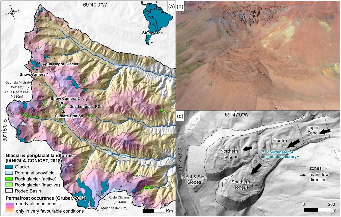
Fig. 1 A) Rock glacier and glacier distribution in the high-altitude catchment of Agua Negra River, which is part of the Rodeo basin and located in the Dry Andes of Argentina (30S and 69W). The upper Rodeo basin is characterized by a distribution of (peri)glacial landforms representative of the region, the very limited presence of vegetation and the absence of populated areas. Landforms are inventoried by IANIGLA- CONICET (2018) and displayed on top of the permafrost occurrence map by Gruber (2012) and a TanDEM-X-based hillshade. B) Photo of Dos Lenguas rock glacier taken with a Phantom 4 RTK drone, March 2022. C) Geomorphological zones slightly adapted after Halla et al. (2021) and displayed on top of a Pléiades-based DEM of 1 m resolution. The Pléiades DEM is based on tristereo, panchromatic Pléiades imagery acquired between February 13th and 20th, 2023. For more information, see Stammler et al. (2024). Snow camera and climate station locations in A), the coordinate used for the extraction of ERA5 data provided through meteoblue history+ in C).
© Stammler et al. 2025
Alle Bilder in Originalgröße herunterladen
Der Abdruck im Zusammenhang mit der Nachricht ist kostenlos, dabei ist der angegebene Bildautor zu nennen.
For more publications of the Geomorphology and Environmental Research Group please go to our research section.